

Site Monitoring
Lucky Drone Services can provide regular aerial updates to your project that can help you stay informed, even when you’re not on site. If you’re managing a project remotely and need consistent updates, Lucky Drone Services provides reliable aerial monitoring to document progress, site conditions, and key milestones.
Our drones deliver high-resolution photos and video that help contractors, owners, and stakeholders stay aligned throughout the build.
Aerial Photos & Video
High-resolution aerial photos up to 100MP and smooth, stabilized video up to 6K provide a clear view of active work areas, equipment placement, access routes, and overall site conditions. These visuals are ideal for progress reports, internal coordination, stakeholder updates, marketing use, and long-term documentation. Our imagery is captured consistently to ensure reliable comparisons throughout each phase of your project. You can view our portfolio here.
Scheduled Progress Flights
We can conduct recurring drone flights on a schedule that fits your project timeline—weekly, bi-weekly, monthly, or milestone-based. By flying consistent routes and angles, we create a reliable visual record that shows how the site evolves over time. These scheduled flights help reduce guesswork, support accurate reporting, and give project teams dependable insight into ongoing work without disrupting site operations.
Progress Comparison
By capturing imagery from the same locations, paths and angles during each flight, we make it easy to compare site conditions over time. We can provide side-by-side or interactive progress visibility options, helping to confirm completed work, track production pace, and clarify timelines for owners and stakeholders. Progress comparison imagery can also support internal reviews, change discussions, and documentation if questions arise later in the project.

Photo - Visit 1

Photo - Visit 2
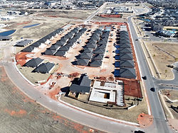
Photo - Visit 3
Video - Visit 1
Video - Visit 2
Visit comparison slider (click and slide < > bar to manually compare)
Visit comparison slider (click and slide < > bar to manually compare)
Orthomosaic Site Maps (Non-Survey Grade)
We can also provide non-survey grade orthomosaic maps that give a detailed overhead view of your project site. These maps are intended for visual reference, planning, and communication — not for engineering or legal measurements however they are great resources for viewing site progress and estimating distances, volumes and elevations. We can provide raw geo-referenced images that you can use in your own GIS software or we can provide some basic online tools you can use to measure progress.

Basic distance measurement tool (estimated horizontal relative accuracy ~ 1 meter)

Basic volume measurement tool (estimated 98-99% accuracy)
Remote Visibility
Drone monitoring gives project managers, owners, and stakeholders a clear view of the job site without needing to be physically present. Aerial photos and video allow teams to review site conditions, verify progress, and stay informed from anywhere. This reduces unnecessary travel, saves time, and ensures decision-makers have up-to-date visuals to support planning, coordination, and communication throughout the project. For ongoing monitoring projects, Lucky Drone Services can provide a secure, dedicated project webpage where you can view the most recent photos, videos, and maps in one place. This private site makes it easy to review current progress, share updates with stakeholders, and reference past flights without managing large file transfers.
Social Media Products
In addition to documentation and progress tracking, aerial photos and video from your project can be used as powerful marketing assets. High-quality visuals help showcase project scale, craftmanship, and momentum throughout the different project phases. Many clients use drone imagery for website content, social media updates, proposals, investor presentations, and future project bids. Capturing progress at key milestones allows you to build a visual story of the project from start to finish, adding long-term value beyond day-to-day monitoring.
Video Timelapse of progress, excellent for marketing and social media!
An annotated 360 spherical photo is a great way to communicate the local environment and planned features. This can be featured on your website and social media.
Why Projects Use Drone Monitoring?
-
Clear project visibility: Aerial views provide an overall understanding of site conditions that ground-level photos often miss.
-
Improved communication: Share visuals easily with owners, subcontractors, and stakeholders to keep everyone aligned.
-
Progress accountability: Consistent documentation helps confirm completed work and track production pace.
-
Early issue identification: Spot access challenges, material staging issues, or workflow conflicts before they cause delays.
-
Reduced site visits: Minimize unnecessary travel while still staying informed on daily and weekly progress.
-
Historical record: Maintain a visual timeline of the project from start to finish for reference, reporting, or future planning.
We offer flexible pricing and scheduling options to fit your specific needs. Weather you need a regularly scheduled update or a one time visit, we can work to fit your needs. We also do video and photo editing so we can tailer the deliverables to fit your needs. We would love to discuss your specific needs, click the "Lets Chat" button or fill out our get a quote form by clicking the button below.